Loading... Please wait...
Categories
 New Products
-
$550.00$485.00
-
$680.00$585.00
-
$680.00$635.00
-
$560.00$465.00
-
$560.00$465.00
Our Newsletter
![]()

![]()
- Home
- Raymarine Electronics
- Raymarine Gps
- Raymarine A70 Chartplotter/Fishfinder 6.4'' U.S. Charts E62190-US
- Home
- Raymarine Electronics
- Raymarine Multifunction Display
- A-Series Chartplotters & Chartplotter Fishfinders
- Raymarine A70 Chartplotter/Fishfinder 6.4'' U.S. Charts E62190-US
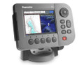
Raymarine A70 Chartplotter/Fishfinder 6.4'' U.S. Charts E62190-US

)
RRP:
Your Price:
$1,440.00
(You save $307.00)
SKU:
E62190-US
Brand:
Condition:
New
Weight:
1.46 KGS
Shipping:
Free Shipping
Product Description
Brand New
Raymarine A70 Chartplotter
A-Series Multifunction Display
Navigation Systems
Preloaded with U.S. Costal Charts
(E62190-US)

|
The Raymarine A70D Chartplotter/Fishfinder is a powerful advanced chartplotting navigation system combined with Raymarine's award winning HD digital Fishfinder.The display is a 6.4” high resolution color VGA that is viewable even in direct sunlight. The special waterproof construction make the A70D a perfect fit for open cockpits and center consoles. This A70D Chartplotter (E62190-US) is already preloaded with U.S. Costal charts. Howeverusing the built-in card reader you can simply plug any charts card like NAVIONICS Gold, NAVIONICS Platinum or HOTMAPS and upgrage your chartplotting to 3D bathymetric views, satellite photo maps, panoramic port photos, dynamic tides & currents, enhanced coastal points of interest and more!Each Raymarine A70 Chartplotter features a high sensitivity internal WAAS GPS receiver built into the display so no extra antenna or cables are required. Simply mount the unit on your dash or console and get excellent GPS pinpoint chartplotter accuracy. For situations where an external antenna is needed, you can add a RayStar 125 GPS antenna. Combine GPS and VHF technology for added situational awareness and safety. The A70 utilises DSC position polling (with DSC equipped VHF) and AIS target tracking (with optional AIS250) right on your chart The A70 Chartplotter comes with a tilt and swivel bracket so you can easily change it's position for best viewing. Easily turn the lever to the other side and quick release the A70 to take it with you when you leave the boat. The built-in cable management system keeps your cables neat and tidy and also prevents water going down your console. Once the A70 is off the boat the the cables are safely left with protective cable caps. The Display can be also console mounted with a special included kit. You can add the SR50 weather receiver and get a full graphical marine weather forcast to your A70. Using SIRIUS Satellite weather technology (US only) the A70 gets the most recent forecast information including weather radar, storm tracks, winds, lightning, temperatures of sea surface, surface pressure, wave heights and more. The A70 is also SIRIUS Satellite radio capable. By connecting the SR50 to your boat's stereo you will get over 130 channels of satellite radio entertainment, commercial free music, sports, news and more. You have full control of channels and volume with the A70 keypads The Raymarine A70 Chartplotter comes packaged with a tilt & swivel bracket, suncover, power/NMEA cable, and instruction manual. The A70 is also SeaTalkNG capable allowing for engine monitoring with compatible engines. With SeaTalkNG you can even activate and control your Raymarine X- Series SmartPilot directly from the A70’s chartplotter. |
Raymarine A70 Chartplotter Features:A70 6.4" Chartplotter
A70 Chartplotter
A70 SIRIUS Weather & Audio (US only)
A70 Engine Monitoring
Raymarine A70 (E62190-US) 6.4 " Multifunction Display - U.S. Coastal Charts Specifications:General
AIS
Chartplotter
Instrument and Engine Data
Interfaces
NAVTEX
|
Product Videos
A-Series Music Promo.flv (01:01)
A Taste of Incredicle Raymarine A-Series Multifunctional Displays
-
 A-Series Music...A Taste of Incredicle Raymarine A-Series Multifunctional Displays
 -
 Raymarine A-Se...Raymarine A-Series multifunctional dispays. GPS Chartplotters ...
 -
 Raymarine A-Se...Raymarine A-Series multifunctional dispays. GPS Chartplotters ...
 -
 Raymarine A-Se...Raymarine A-Series multifunctional dispays. GPS Chartplotters ...