Loading... Please wait...
Categories
 New Products
-
 $6,000.00
-
 $2,400.00
-
 $5,217.00
-
 $30,000.00
-
 $600.00
Our Newsletter
![]()

![]()
- Home
- Garmin Marine Electronics
- Garmin GPSMAP® 1222xsv Plus Chartplotter/Sonar Worldwide Basemap (010-02322-02)
- Home
- Garmin Marine Electronics
- Garmin Chartplotters
- Garmin GPSMAP® 1222xsv Plus Chartplotter/Sonar Worldwide Basemap (010-02322-02)

, $12,000.00 (http://www.marine-electronics-shop.com/garmin-gpsmap-1222xsv-plus-chartplotter-sonar-worldwide-basemap-010-02322-02/))
Product Description
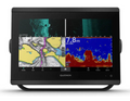
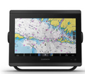
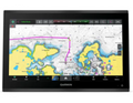
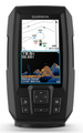
Garmin GPSMAP® 1222xsv Plus Chartplotter/Sonar Worldwide Basemap
(010-02322-02)

The Garmin GPSMAP® 1222xsv Plus delivers premium marine navigation with a stunning 12” sunlight-readable display. Equipped with SideVü, ClearVü, and CHIRP sonar, it ensures ultra-clear underwater imaging. With the included Worldwide Basemap, advanced networking, and built-in Wi-Fi, it’s perfect for offshore fishing, coastal cruising, or competitive sailing. Intuitive controls, fast chart redraws, and seamless integration with radar, autopilot, and sensors make it an indispensable tool for any serious boater.Garmin GPSMAP® 1222xsv Plus Chartplotter/Sonar Worldwide- Description
The GPSMAP® 1222xsv Plus offers cutting-edge sonar technology, high-speed mapping, and total marine system integration—providing unmatched clarity, precision, and control for both recreational and professional mariners.
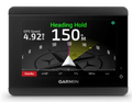
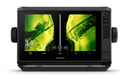
Brilliant 12” Display The high-resolution, sunlight-readable display ensures excellent visibility in all lighting conditions, even under direct sunlight or when wearing polarized sunglasses. Integrated SideVü and ClearVü Sonar Get near-photographic images of structures and fish below and to the sides of your boat for improved targeting and navigation. Traditional CHIRP Sonar Experience superior target separation and detail with Garmin’s advanced CHIRP sonar technology for precise fish tracking. Worldwide Basemap Included Navigate confidently anywhere in the world with preloaded base mapping and optional premium BlueChart® g3 cartography. Radar Compatibility Supports Garmin’s full range of marine radars for enhanced situational awareness and collision avoidance. Autopilot Integration Easily connect to Garmin autopilot systems for smooth course adjustments and hands-free cruising. NMEA 2000® & NMEA 0183 Networking Seamlessly integrate with sensors, AIS, VHF radios, and engine data for a unified marine network. Built-in Wi-Fi® Connect to the ActiveCaptain® app for software updates, map downloads, and trip planning on your smartphone. Panoptix™ LiveScope™ Support Add live, real-time sonar imaging to see fish movements with unmatched clarity. Fast, Responsive Interface The updated processor ensures smooth panning, fast zooming, and near-instant chart redraws. SailAssist™ Features Get laylines, enhanced wind data, and pre-race guidance tools for competitive sailing. Video Input Support View camera feeds directly on your display for added safety and docking assistance. Customizable Screen Layouts Tailor display panels to show exactly the information you need for different boating activities. Durable Marine Design Built to withstand harsh marine environments with rugged waterproof housing (IPX7). Multi-Station Sharing Share sonar, charts, radar, and user data across multiple Garmin MFDs on your vessel.
Garmin GPSMAP® 1222xsv Plus Chartplotter/Sonar Worldwide - Key FeaturesTriple Sonar Technology SideVü, ClearVü, and CHIRP sonar deliver detailed underwater views for anglers and divers. Worldwide Navigation Coverage Navigate with confidence using the included Worldwide Basemap and optional premium charts High-Speed Processing Enjoy faster screen redraws and ultra-responsive touch controls. Full System Integration Control radar, autopilot, sonar, and more from a single display. Live Sonar Ready Compatible with Garmin Panoptix™ and LiveScope™ for real-time underwater visuals. Sailing Optimization Built-in SailAssist™ tools improve racing performance and cruising efficiency. Wireless Connectivity ActiveCaptain® app support enables map updates and trip sharing. Multiple Networking Options NMEA 2000® and NMEA 0183 connections allow full marine integration. Video Monitoring Connect cameras for docking assistance and onboard monitoring. Custom Display Layouts Personalize split screens for fishing, cruising, or sailing needs Multi-Station Networking Share charts and sonar with other compatible Garmin units Rugged & Waterproof IPX7-rated design ensures reliability in tough marine conditions. Chart Upgrades Add BlueChart® g3 Vision maps for 3D views, aerial photography, and fishing charts. User-Friendly Interface Simplified menus and intuitive operation make navigation effortless. Advanced Autopilot Control Integrates with Garmin autopilot systems for safer, easier navigation. Future-Ready Compatibility Supports latest Garmin marine technologies and accessories.
Garmin GPSMAP® 1222xsv Plus Chartplotter/Sonar Worldwide - What Is In The Box
Garmin GPSMAP® 1222xsv Plus Chartplotter/Sonar Worldwide - SpecificationsGeneral
Maps & Memory
Sensors
Built-in Maps
Optional Map Support
Chartplotter Features
Electrical Features
Sonar Features
Connections
|