Loading... Please wait...
Categories
 New Products
-
 $6,000.00
-
 $2,400.00
-
 $5,217.00
-
 $30,000.00
-
 $600.00
Our Newsletter
![]()

![]()
- Home
- Garmin Marine Electronics
- Garmin GPSMAP® 9019 Chartplotter Worldwide Basemap (010-02673-00)
- Home
- Garmin Marine Electronics
- Garmin Chartplotters
- Garmin GPSMAP® 9019 Chartplotter Worldwide Basemap (010-02673-00)

, $30,000.00 (http://www.marine-electronics-shop.com/garmin-gpsmap-9019-chartplotter-worldwide-basemap-010-02673-00/))
Product Description
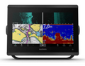
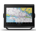
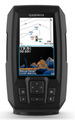
Garmin GPSMAP® 9019 Chartplotter Worldwide Basemap
(010-02673-00)

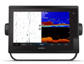
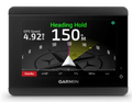
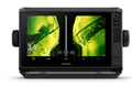
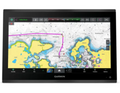
Experience elite marine navigation with the Garmin GPSMAP® 9019, a high-performance chartplotter featuring a stunning 19" full HD touchscreen and worldwide basemap coverage. Designed for serious mariners, it offers seamless integration with radar, sonar, autopilot, and more. With lightning-fast processing, intuitive controls, and advanced connectivity, the GPSMAP® 9019 delivers unmatched situational awareness and precision for offshore cruising, sport fishing, and commercial marine operations.Garmin GPSMAP® 9019 Chartplotter Worldwide Basemap- DescriptionThe GPSMAP® 9019 combines a sleek 19" touchscreen display with powerful navigation tools, global basemap coverage, and full system integration—making it the ultimate command center for your vessel.
Ultra-Wide 19" Touchscreen Display The GPSMAP® 9019 features a vibrant full HD display with edge-to-edge glass and pinch-to-zoom functionality. Its large format ensures clear visibility in all lighting conditions. Worldwide Basemap Coverage Preloaded with a global basemap, this chartplotter provides essential navigation data for international waters. Expand with premium charts for enhanced detail and functionality. High-Speed Processing Enjoy rapid chart redraws and smooth transitions thanks to a powerful processor. Multitask effortlessly between sonar, radar, and autopilot interfaces. Advanced Marine Navigation Supports detailed chart plotting, route planning, and real-time vessel tracking. Ideal for offshore navigation, coastal cruising, and commercial marine use. Radar and Sonar Integration Compatible with Garmin’s radar and sonar systems, including CHIRP and Panoptix™. Gain real-time underwater and surface awareness for safer navigation. Autopilot Connectivity Seamlessly integrates with Garmin autopilot systems for hands-free control. Adjust heading, follow routes, and monitor performance directly from the display. NMEA 2000 and NMEA 0183 Support Connect with a wide range of marine electronics using industry-standard protocols. Share data across your entire vessel network. Wireless and Bluetooth Connectivity Built-in Wi-Fi and Bluetooth enable software updates, data sharing, and remote control via mobile devices. Stay connected on and off the water. Smart Notifications and App Integration Receive texts, calls, and app alerts directly on your chartplotter. Compatible with Garmin Helm™ and ActiveCaptain® for remote access and planning. Customizable Interface Tailor your display layout with split-screen views and custom data overlays. Prioritize the information that matters most to your journey. Rugged Marine-Grade Build Built to withstand harsh marine environments, the GPSMAP® 9019 is water-resistant and corrosion-proof. Ready for salt spray, sun, and rough seas. Expandable System Architecture Add radar, sonar, cameras, and more to create a fully integrated marine command center. Scalable for vessels of all sizes. Real-Time Environmental Data Access tide tables, currents, wind data, and more. Stay informed and make smarter navigation decisions. Multi-Vessel Monitoring Monitor multiple engines, tanks, and sensors from a single interface. Ideal for commercial fleets and large yachts. Easy Installation and Mounting Flush or flat mount options with included hardware. Designed for professional-grade installation with minimal hassle.
Garmin GPSMAP® 9019 Chartplotter Worldwide Basemap - Key Features19" Full HD Touchscreen Large, high-resolution display with intuitive touch controls for effortless operation in any condition. Worldwide Basemap Preloaded global coverage with essential navigation data; upgradeable with premium BlueChart® g3 and g3 Vision® charts. High-Speed Processor Fast redraws and smooth transitions between screens, even when running multiple systems simultaneously. Radar Compatibility Supports Garmin xHD2 and Fantom™ radar systems for enhanced situational awareness. Sonar Integration Works with CHIRP, ClearVü, SideVü, and Panoptix™ sonar for detailed underwater imaging. Autopilot Control Full integration with Garmin autopilot systems for route following and heading adjustments. NMEA 2000/NMEA 0183 Support Connects with a wide array of marine electronics for seamless data sharing and control. Wireless Connectivity Wi-Fi and Bluetooth enable remote access, updates, and smart notifications. Smart Notifications Receive calls, texts, and app alerts directly on your display when paired with a compatible smartphone. Garmin Helm™ App Support Control your chartplotter remotely from a tablet or smartphone using the Garmin Helm™ app. ActiveCaptain® Compatibility Plan routes, download charts, and sync data with Garmin’s ActiveCaptain® mobile app. Customizable Display Split-screen views and data overlays let you personalize your navigation experience. Rugged Design Marine-grade construction with water-resistant housing for durability in extreme conditions. Expandable System Add cameras, sonar, radar, and more to build a complete marine electronics suite. Real-Time Data Access View tides, currents, wind, and other environmental data for smarter navigation. Multi-Engine Monitoring Track engine performance, fuel levels, and other metrics from a single interface. Garmin GPSMAP® 9019 Chartplotter Worldwide Basemap - What Is In The Box
Garmin GPSMAP® 9019 Chartplotter Worldwide Basemap - SpecificationsGeneral
Maps & Memory
Sensors
Optional Map Support
Chartplotter Features
Electrical Features
Sonar Features
Connections
|