Loading... Please wait...
Categories
 New Products
-
$599.00$515.00
-
$530.00$460.00
-
$680.00$585.00
-
$680.00$635.00
-
$560.00$465.00
Our Newsletter
![]()

![]()
- Home
- Garmin Marine Electronics
- Garmin Handheld Navigators
- Garmin GPSMAP 78s Handheld Navigator - 010-00864-01
- Home
- Garmin Marine Electronics
- Garmin Handheld Navigators
- Gramin GPSMAP 78 Series
- Garmin GPSMAP 78s Handheld Navigator - 010-00864-01
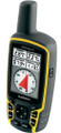
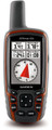
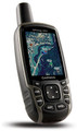
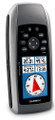
Garmin GPSMAP 78s Handheld Navigator - 010-00864-01

)
Product Description
Brand New In Box
Garmin GPSMAP 78s
GPS Handheld Navigator
(010-00864-01)

Garmin GPSMAP 78s is the best rugged marine handheld navigator for watersports enthusiasts, Mariners and boaters. A 65K colors transflective TFT display that is viewable in direct sunlight, a high sensitivity GPS receiver and a 3-Axis precise Compass makes the GPSMAP 78s suitable for navigating both in land and at sea. It is IPX7 waterproof and if it falls into water it will float!
Utilizing an advanced 3-axis electronic compass with tilt-compensation the GMSPAM 78s will show your exact bearing as you go no matter how you hold it while it's barometric altimeter will help you keep track of altitude and provide data of developing weather conditions. The GPSMAP 78 will show your exact bearing as you go. You can twist it, tilt it or turn it and the device will always adjust to keep you headed in the right track.
Garmin GPSMAP 78s Navigator supports HotFix® satellite prediction and using its WAAS-enabled GPS receiver you will be able to know your exact location anytime even under heavy cover or hard weather conditions..
Adding additional maps to the GPSMAP 78s is simple and easy using the Micro SD slot on the device. You can add any of the wide array of Garmin's marine and road maps like BlueChart G2 for mariners detailing offshore data such as shaded depth contours, 24K or 100K TOPO Maps for more detailed topographies, City Navigator NT® for street maps with address lookup or Garmin Customs Map software. Subscribing to BirdsEye™ Satellite Imagery will provide downloading high-resolution satellite images of places, trails and landmarks to the GPSMAP 78s.
The GPSMAP 78s like most Garmin's handheld GPS receivers is supporting Photo-navigation - navigating to geotagged photos. It also supports 2000 waypoints, 200 routes and there is an option to program an alarm when you reach a desired distance before your waypoint.
Wireless data transfer is supported by the Garmin GPSMAP 78s and lets you wirelessly transfer data to and from a compatible Garmin's handheld GPS navigators. Wirelessly sharing info like caches, route and tracks is accomplished with a few simple steps.
Connecting the GPSMAP 78s navigator through the internet to Garmin Connect™ allows you to store and analyze your activities. You can share, compare and explore other Gamin users and their voyages information. Integration to Facebook and Twitter are fast and easy so you can keep your loved one informed on your where about and to share your experiences.
The Garmin GPSMAP 78s supports paperless geocaching. By downloading geocaching GPX files to your handheld navigator you save manual insertion of coordinates and carrying paper printouts of your travel. The information is uploaded directly to the device including all necessary data like description, logs, hints and tips of the waypoints.
GPSMAP 78s is equipped with a new High-Speed USB connection that will make transferring data to and from your computer faster and easier. The UBS plug is covered and protected.
The Garmin GPSMAP 78s Marine handheld is NMEA0183 compatible. It has built-in Hunt/Fish calendar, Tides tables, Sun & Moon information and Area Calculations. It operates with 2 AA batteries featuring colorful maps, and float over water.
| Garmin GPSMAP 78s Left View | Garmin GPSMAP 78s Front View | Garmin GPSMAP 78s Right View |
|
|
|
|


Garmin GPSMAP 78s - What's In The Box:
- GPSMAP 78s Handhelp Navigator Device
- Wrist Strap
- USB Cable
- Operating Manual
Garmin GPSMAP 78s Physical & Performance: |
|
| Unit dimensions, WxHxD: | 2.6" x 6.0" x 1.2" (6.6 x 15.2 x 3.0 cm) |
| Display size, WxH: | 1.43" x 2.15" (3.6 x 5.5 cm); 2.6" (6.6 cm) |
| Display resolution, WxH: | 160 x 240 pixels |
| Display type: | transflective, 65-K color TFT |
| Weight: | 7.7 oz (218.3 g) with batteries |
| Battery: | 2 AA batteries (not included); |
| Battery life: | 20 hours |
| Waterproof: | yes (IPX7) |
| Floats: | yes |
| High-sensitivity receiver: | yes |
| Interface: | high-speed USB and NMEA 0183 compatible |
Garmin GPSMAP 78s Maps & Memory: |
|
| Basemap: | yes |
| Preloaded maps: | no |
| Ability to add maps: | yes |
| Built-in memory: | 1.7 GB |
| Accepts data cards: | microSD™ card (not included) |
| Waypoints/favorites/locations: | 2000 |
| Routes: | 200 |
| Track log: | 10,000 points, 200 saved tracks |
Garmin GPSMAP 78s Features & Benefits: |
|
| Automatic routing (turn by turn routing on roads): | yes (with optional mapping for detailed roads) |
| Electronic compass: | yes (tilt-compensated, 3-axis) |
| Barometric altimeter: | yes |
| Geocaching-friendly: | yes (paperless) |
| Custom maps compatible: | yes |
| Photo navigation (navigate to geotagged photos): | yes |
| Hunt/fish calendar: | yes |
| Sun and moon information: | yes |
| Tide tables: | yes |
| Area calculation: | yes |
| Custom POIs (ability to add additional points of interest): | yes |
| Unit-to-unit transfer (shares data wirelessly with similar units): | yes |
| Picture viewer: | yes |
|
Garmin Connect™ compatible (online community where you analyze, categorize and share data): |
yes |
Press to see comparing table between the 3 models of Garmin GPSMAP 78 Series
Warranty Information
Worldwide Free Shipping
365 days Return Policy