|
Back to Top
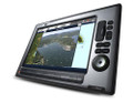
Raymarine C120W Chartplotter Features:
- multiple view of several navigation sources on a single display
- connect sensor, receiver or appropriate device to have the C120W become into a full feature chartplotter, digital fishfinder, sattelite weather and radio, radar or on board video system.
- Sunlight Viewable display with improved vivid colors and contrast in all lighting conditions
- High WVGA resolution - 1280x800 pixels
- UniControl™ pad for easy display and menu navigation
C120W SeaTalkhs Networking
- Super fast 100 MB Networking
- Dual display system - for sharing views of chartplotter, fishfinder, radar, weather and more across two C-Series Widescreen displays
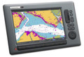
C120 (E62113-EU) Chartplotter
- Preloaded with NAVIONICS Europe Costal Cartography - European Charts.
- Internal high sensitivity GPS sensor
- Optional using Charts card for 3D views and Satellite photo maps.
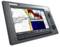
C120 Digital Fishfinder
- Connect to a sounder module (DSM30 or DSM300) using SeaTalkhs networking.
- Patented HD Digital sonar technology for precise targeting of fish and bottom structure.
- Four fishfinder presets for one touch access to favorite fishfinder view
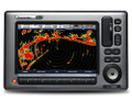
C120 Radar
- Compatible with SeaTalkhs digital radomes
- HD Digital and Super HD Digital open array compatibility
- Auto GST technology to provide hands off operation
- Dual Range radar when used with HD or Super HD Digital Arrays
C120 SIRIUS Weather & Audio
- SIRIUS Satellite weather and radio functionality with optional SR100 receiver
- View up to the minute animated weather radar, forecasts, storm warnings and more delivered instantly via satellite.
- Graphical Nowrad radar, sea surface temps, storm tracks, and more.
- SIRIUS Satellite Radio functionality right on your C-Series Widescreen display. Set reminders for favorite songs and artists on over 100 SIRIUS Satellite Radio channels.
C120 Video Integration
- Display remote video sources from CCTV cameras, entertainment systems, and more.
- Plug and play connectivity with Raymarine CAM100 or CAM50 marine cameras
C120 Instrument Integration
- Network with SeaTalk, SeaTalk2, SeaTalkng, SeaTalkhs, NMEA 0183 or NMEA 2000 instruments.
- Display data from NMEA 2000 compatible engine systems.
C120 Autopilot Integration
- Activate and control Raymarine Smartpilot X-Series Autopilots directly from the chartplotter interface
Back to Top
Raymarine C120W (E62113-EU) 12.1" Multifunction Display - European Charts Specifications
General
|
| |
Data Display Capabilities
|
GPS, Chartplotter, Fishfinder, Radar, External Video, CDI(Course Deviation Indicator), and customizable Data Bar display |
|
| |
Dimensions |
C120W: 14.98" x 9.66" x 6.14" (380.4 x 245.4 x 155.9)
Depth measurement includes powercable
|
|
| |
Display (LCD) Size |
C120W: 12.1" |
|
| |
Display Colors |
16.7M |
|
| |
Display Resolution |
C120W: 1280 x 800 pixels (wide XGA) |
|
| |
Display Type |
Sunlight viewable color TFT LCD |
|
| |
Mounting Methods |
Console mounting hardware included. Trunnion mounting kit sold separately |
|
| |
Operating Temperature Limits |
14°F to 122°F (-10°C to 50°C) ambient air at 95% RH |
|
| |
|
|
|
| |
|
|
|
| |
Power Consumption |
32 Watts (typical) |
|
| |
Voltage Range |
10.7–32 volts (12/24v nominal) |
|
| |
Waterproofing |
CFR46/IPX6 standards |
|
| |
Weight |
C120W:10.5lbs (4.76kg) |
|
| |
Approvals CE - Conforms to FCC - Compliant with |
Essential requirements of 1995/5/EC, 1989/336/EC. CFR47 Parts 2 & 80 |
|
| |
Humidity Limit |
up to 95% at 35°C non-condensing |
|
| |
Display Windows |
Chart, Radar, Fishfinder, CDI, Video, Data, Weather and Engine Monitor |
|
| |
Screen Functions |
Full, half and quarter screens available dependant on function. Also 3 window page with 2 x 1/4 page windows and 1 x 1/2 page window. |
|
| |
Illumination |
Screen and keypad: 0 to 100% in 64 steps Day/Night Mode |
|
| |
Languages |
English (US), English (UK), Italian, French, Spanish, German, Norwegian, Dutch, Swedish, Danish, Portuguese, Finnish, Icelandic, Chinese, Russian, Greek, Japanese, Korean |
|
| |
System Alarms |
Alarm Clock, Anchor, Arrival, Deep, Shallow and Fishing Depth, MOB, Offtrack, Temperature, Timer |
|
| |
Navigation Alarms |
Arrival Alarm, Offtrack XTE Alarm |
|
Interfaces
|
| |
Network Configurations |
Single or dual display configurations |
|
| |
SeaTalkhs Network |
2 ports |
|
| |
|
Supports 8 devices |
switch required |
| |
NMEA interface |
3 inputs (configurable baud rate) |
|
| |
|
2 outputs |
|
| |
NMEA 0183 Input |
GLL, GGA, GLC, GTD, VTG, BWC, BWR, RMA, RMB, RMC, XTE, VHW, HDG, HDM, HDT, DBT, DPT, APB, VLW, MWV, WPL, RTE, DSC and ZDA. Selectable to 4800, 4800 Navtex, 9600 Navtex or 38,400 AIS |
|
| |
NMEA Output - User selectable |
APB, BWC, BWR, DBT, DPT, GGA, GLL, MTW, RMA, RMB, RMC, RSD, TTM, VLW, VHW, VTG, WPL, VHF/DSC and ZDA |
|
| |
Seatalk Interface |
1 port |
|
| |
SeaTalk Input |
Depth,SOG,COG, Position, Waypoint Number, Range/ Bearing, TTG, Boat Speed, Time, XTE, Heading, Wind, Data, Log/Trip, Pilot Status, Temperature, MOB and Cursor Position |
|
| |
SeaTalk Output |
Cursor Data, Guard Zone and Navigational Data bridged from NMEA |
|
| |
SeaTalk2/NMEA2000 |
1 port |
Also supports SeaTalkng
|
| |
Video Input |
Composite Video (NTSC or PAL) Input (BNC connector) |
|
GPS
|
|
GPS Type |
Internal High Sensitivity Receiver |
|
| |
Channels |
12 |
|
| |
Frequency |
1.575GHz (L1) |
|
| |
Sensitivity |
-159dBm (tracking), -142dBm (acquisition) |
|
| |
SBAS Support |
WAAS / EGNOS Compatible |
|
| |
Horizontal Position Accuracy |
|
|
| |
Speed Accuracy |
|
|
| |
Antenna |
Helical antenna for even sensitivity across all orientations |
|
Chartplotter
|
| |
Cartography |
Embedded with Navionics ready-to-navigate Europe Costal Cartographys: European Charts |
|
| |
|
Compatible with Navionics Charts on CompactFlash cards |
|
| |
Chart Scaling |
1/32nm (if cartographic detail is available) to 4000nm |
|
| |
Waypoints |
3000 waypoints entered via cursor, lat/lon, range and bearing from present position or at boat’s position. 16 character name can be assigned. Waypoint symbols and groups. Additional storage available on CompactFlash cards. |
|
| |
Waypoint Transfer |
Waypoints database via NMEA and CompactFlash cards. Software also available to convert waypoints to Excel file. |
|
| |
Man Overboard (MOB Mode) |
Mark placed with course line; readout shows range, bearing, lat/lon of MOB and time elapsed since MOB. |
|
| |
Presentation Modes |
Head up, Course up or North up (selectable True or Mag-netic) Relative, Autorange or True Motion Screen offset Radar or 3D synchronization |
|
| |
Routes |
A route plan may contain up to 50 waypoints. Up to 150 routes can be stored in the units internal memory. Additional storage available on CompactFlash cards. SmartRoute to create a route from track history. |
|
| |
Track History |
15 tracks with up to 3000 points in each can be stored in the units internal memory. Track optimization reduces number of points used or user selectable time or distance interval. Additional storage available on CompactFlash cards. |
|
| |
Radar/Chart Overlay |
Radar image can be overlaid on all screen charts |
|
| |
Radar/Chart Synchronization |
To synchronize radar range and chart scale |
|
| |
3D/Chart Synchronization |
To synchronize 3D and 2D chart scales and orientation |
|
| |
Aerial Overlay |
Overlay of aerial photography on the chart |
|
| |
AIS Overlay |
Switch AIS symbols on/off. Display heading/speed vectors and ROT. View detailed AIS data, safety critical target data, ALR and SRM messages. Set up a safe zone. |
|
| |
Navigation Information |
Own boats position in lat/lon, XTE, TTG and SOG/COG selectable. Bearing and distance to waypoint. Bearing and distance to cursor and ETA. |
|
| |
3D Presentation Modes |
Active motion mode, planning mode, Adjust rotation and pitch, port, starboard, forward and aft view, multiple views, Vessel offset |
|
| |
3D Display |
Declutter, Transducer cone, Depth scale, Waypoint name, Adjust exaggeration, 3D view locator |
|
Fishfinder
|
| |
Transducer |
Transom-mount, in-hull or thru-hull options |
|
| |
Digital Sounder Modules |
Compatible with the DSM30 and DSM300 |
|
| |
Receiver Type |
Patented Raymarine HD Digital receiver technology |
|
| |
Power Output |
Dependant on Digital Sounder Module |
|
| |
Frequency |
Dependant on Digital Sounder Module |
|
| |
Alarms |
Fish Alarm, Fish Depth Alarm, Shallow and Deep Fish Limit |
|
| |
A-Scope Display |
Displays Sonar Returns in real time |
|
| |
Bottom Coverage Display |
Shows the diameter of the transducer beam where it meets the bottom. |
|
| |
Bottom Lock |
Displays echoes directly above the bottom |
|
| |
Range Markers |
Easily see how far the boat is from a target on the echo sounder screen |
|
| |
Target Detection |
Sonar fish echo with target depth readout |
|
| |
Zoom |
2,3,4x and user programmable Zoom Scales |
|
Radar
|
| |
Radar Support |
Support for all Digital, HD Digital & Super HD Digital Radars |
|
| |
Image Type |
Color Radar Support (HD & SHD Radars Only) |
|
| |
Range Scales (Range Rings) |
1/8 (1/16) nm to 72 (12) nm dependant on scanner. Performance limited by scanner type and position. |
|
| |
Range Ring Accuracy |
Better than +/- 1.5% of the max. range scale in use, or 22m (72 ft.), whichever is the greatest. |
|
| |
Bearing Accuracy |
+/- 1° |
|
| |
Variable Range Markers |
2 x VRM’s, readout nm, sm, km |
|
| |
Electronic Bearing Lines |
2 x EBL’s, floating if required, resolution 1° |
|
| |
Bearing Scale |
360° graduated at 10° intervals 2° small ticks 10° large ticks |
|
| |
Minimum Range |
23m (25 yds) |
|
| |
Range Discrimination |
23m (25 yds) |
|
| |
Presentation Modes |
Head up, Course up or North up (selectable True or Mag-netic) Relative or True Motion |
|
| |
Scanner Control |
Interference rejection, standby/transmit modes, pulse selection, Tune, Rain, FTC and Sea controls, with selection of manual or automatic control of gain, sea clutter and tune (Auto GST) |
|
| |
Compass Input |
NMEA 0183 (required for fast heading data, suitable for MARPA), or SeaTalk |
|
| |
Waypoint Display |
Create waypoints and target waypoint displayed with User control of symbols and groups |
|
| |
MARPA |
Manual acquisition of up to 25 targets (dependent upon scanner type), automatic tracking, dangerous target alarms, safe zone, target history, true or relative vectors, CPA graphics and indication of target speed/ course, bearing/ range, CPA and TCPA. |
|
| |
Guard Zone Alarm |
2 guard zones, selectable sensitivity level, audible alarm |
|
| |
Automatic Tuning |
Auto control of gain, sea clutter and tune |
|
| |
Off Center Function |
In Relative Motion, 1/3 or 2/3 |
|
| |
Wakes |
10s, 30s, 1 min, 5 min & 10 min options |
|
| |
Target Expansion |
Operator selectable with 2 levels available |
|
| |
Timed TX |
Rotation periods: 10, 20 or 30 scans Repetition periods: 3, 5, 10 or 15 minutes |
|
| |
AIS Overlay |
Switch AIS symbols on/off. Display heading/speed vectors and ROT. View detailed AIS data, safety critical target data, ALR and SRM messages. Set up a safe zone. |
|
Instrument and Engine Data
|
| |
Data Pages |
5 pages available. Pre-defined (Navigation, Waypoint, Route, Fishing or Sailing) or user-configured |
|
| |
Data Available |
Vessel position, active waypoint, TTG, VMG - Waypoint, depth, COG, SOG, heading, speed, set/drift, trip, log, ground log, ground trip, rudder, local time and date, sea temperature, app wind, true wind, VMG wind, ground wind XTE, compass, locked heading, w |
|
| |
Engine Pages |
5 pages available. Pre-defined (engine, engine and fuel, fuel resources, engine and resources, twin engines or triple engine support) or user-configured. |
|
| |
Engine Data |
Tacho, boost pressure, alternator, oil pressure, coolant temperature, engine hours, fuel level (tanks 1 & 2), fuel rate, total fuel, load |
|
AIS
|
| |
AIS Suppport |
Support for class B AIS |
Supports silent mode |
| |
Target Symbols |
Sleeping, activated, selected, dangerous and lost |
|
| |
Target Information |
AIS vectors, buddy tracking, safety critical data and full AIS data. |
|
| |
Collision Avoidance |
Safe zones and safety messages |
|
| |
Alarms |
Local alarm messages, lost targets |
|
NAVTEX
|
| |
Alerts |
Incoming message (selectable categories) |
|
| |
Message List |
Sorting |
|
Weather
|
| |
Type |
SIRIUS Marine Weather |
|
| |
Weather Elements |
Storm cast, waves, Canadian radar, lightning, wind, sea surface temperature, observations stations, city weather, NOWRad, storm tracks, surface pressure |
|
| |
Animated Weather Graphics |
Weather forecast, weather radar history |
|
| |
Weather Reports |
Tropical statements, marine warnings, marine zone forecasts, marine watchbox |
|
General
|
| |
Storage Temperature |
-4°F to 149°F (-20°C to +65°C) ambient air at 95% RH |
|
|
 Loading... Please wait...
 New Products
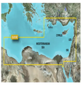 $750.00
 $102.00
 $117.00
 $162.00
 $87.00

)