|
Back to Top
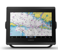
Features and benefits of Garmin GPSMAP 7412xsv 010-01307-02
Special functions for sailing vessels
Garmin GPSMAP 7412xsv supports special functions for sailing, including lay lines, enhanced wind rose, line direction and course over ground, true wind data fields and control "the tide / current / time". Through those indicators you can see at a glance all the important information to consider, including the true and apparent wind angle, demolition, true or apparent wind speed, horizontal or vertical charts and data panel with adjustable data fields.
The clearest scan sonar in the water
Scanning Sonar Garmin DownVü ™ provides for your GPSMAP 7412xsv, almost photographic image of everything that takes place under your boat. Scanning Sonar Garmin SideVü gives a clear image of objects located on the sides of the vessel. You can see detail underwater objects, structure and fish. One transducer combines the traditional sonar Garmin HD-ID sonar and scanning sonar DownVü. In addition, Garmin GPSMAP 7412xsv supports HD-ID for trolling motors with built-in transducers Minn Kota and MotorGuide. Also GPSMAP 7412xsv model includes the function of recording data sonar, which coordinates the sonar echoes with the location of your vessel. Preservation of digital information can then be viewed on a PC using the free HomePort ™ software. Using a cable to exchange user data, you can share your waypoints and routes with other devices.
Garmin Marine Network and NMEA 2000 support
Full compatibility of the GPSMAP 7412XSV with the network allows you to extend the capabilities of your onboard equipment. Garmin GPSMAP 7412xsv supports the radar, autopilot, marine lights, screens, FUSION-Link, sensors, remote sonar modules, digital switches, thermal imaging cameras, wired keyboard GRID. In addition, the device allows communication with other compatible GPSMAP devices, including data radar, sonar module GSD 24 and GSD 26, additional mapping and user data (waypoints, routes, and tracks). User data entered in one chartplotter automatically synced with other chartplotters network.
Location and direction data update 10 times per second
Fast and high-sensitivity receiver 10Hz GPS / GLONASS provides location and direction data update 10 times a second. With Garmin GPSMAP 7412xsv, your movements on the screen will look much smoother. Using this feature, you will be able mark up to 5,000 waypoints with exact coordinates for a safe and fast way back search.
Compatibility with sensors gWind
In the gWind, gWind Wireless and gWind Race sensors, GPSMAP 7412xsv applies double edge technology with 3-bladed propeller. This component is connected to the NMEA 2000 network to a compatible Garmin chartplotter via the GND 10 (bridge "black box").
Multimedia system FUSION-Link
You will be able to control all compatible audio systems FUSION-Link directly from the GPSMAP 7408xsv chartplotter.
Built-in Wi-Fi technology / ANT +
Garmin GPSMAP 7412xsv includes built-in Wi-Fi / ANT® technology for applications Garmin Helm ™ iBlueChart® Mobile.
View and manage the GPSMAP 7412xsv with your smartphone or tablet
Garmin Helm application allows you to view the data and manage the GPSMAP 7412xsv with a compatible smartphone or tablet to enhance the user's awareness of the environment during the voyage. Garmin GPSMAP 7412xsv provides convenient switching between vertical and horizontal orientation of the screen for a variety of mounting options. When using the iPhone® or iPad® you can record video from your chartplotter screen and show it to family and friends. Download the application from App Store ™ or Google Play ™.
Use Apple® device on board using BlueChart Mobile app
Using BlueChart Mobile, a free app from the App Store ™, you can plan the sea routes on the iPad or iPhone, and then transfer them to the Garmin GPSMAP 7412xsv wirelessly.
Improved "Auto-Guide"
Just enter your desired destination, and Garmin GPSMAP 7412xsv will immediately offer you a secure virtual route, built with the low bridges, areas of shallow water, and other obstacles.
An enhanced version 2.0 offers additional features and capabilities. Now you can adjust the calculated route "Auto-Guide", adding the waypoints (stops or targets). You can also view the dangerous points located along the calculated route. Version 2.0 allows Garmin GPSMAP 7412xsv to calculate the time of arrival at any point of the route (this feature is very convenient if the arrival time should be consistent with the time of cultivation of bridges or other events with strict time regime). You have the ability to save "Auto-Guide" routes for future use by writing to the SD ™ memory card cartography BlueChart® g2 Vision®.
Simplified transfer of SOS distress signal
Garmin GPSMAP 7412xsv allows any person, even a stranger with marine electronics and radio communication protocols, in an emergency to get in touch with the Coast Guard. Just click on the SOS button on the touchscreen of GPSMAP 7412xsv and your VHF network will automatically tune on the emergency frequency channel. The screen will show a list of possible situations (fire, man overboard, etc.) After selecting the desired option, on the screen of GPSMAP 7412xsv will appear an approved sample of the distress signal from the vessel with current GPS coordinates. This message, containing all the necessary information will be sent to the Coast Guard.
Sharing Waypoints GPX
If your GPS-navigator, issued not by Garmin, or your waypoints were saved on a portable Garmin navigator , you can easily transfer the data to your GPSMAP 7412xsv, through GPX format of an industry standard. GPX - is a new standard format for exchanging GPS data between different platforms and applications. With this easy-to-use interface technology you can easily exchange data between devices.
Special functions for sailboats
To help you achieve the best results in a sailing race, Garmin GPSMAP 7412xsv provides you a page with the virtual start line and data fields, which display lay lines, time to start and race timer, synchronized with all networked Garmin GPS-devices. Additional features supported include enhanced for sailing compass rose, line direction and course over ground, the demolition of the true and apparent wind parameters, etc. You can also use the built-in connectivity options to access the various marine applications with the help of compatible smartphones or tablet computers.
The transducer of the lower viewing Panoptix ™
One Panoptix bottom view transducer, with three wonderful review mode allows you to watch the fish swimming around your vessel, in real time. Garmin GPSMAP 7412xsv, shows the entire water column, on which you swim, in 3-D mode, from the bottom to the water surface, including all the fish inside. Even without mooving, you'll have the opportunity to observe the objects under the ship in 3-D mode.
LIVEVÜ DOWN mode
GPSMAP 7412xsv displays moving pictures under the sonar vessel in real time. On this screen, purple color indicates the reflected signals from the bait. Old data sonar located on the left.
REALVÜ 3-D DOWN mode
Garmin GPSMAP scans the area below the boat from front to back and from side to side.
Back to Top
Specifications - Garmin GPSMAP 7412xsv 01-01307-02 :
| Physical dimensions |
33.0 x 22.6 x 7.9 cm |
|---|
| Weight |
2.72 kg |
|---|
| Display type |
WXGA display |
|---|
| Display size |
26.2 x 16.3 cm; 30.7 cm diagonal |
|---|
| Display resolution |
1280 x 800 pixels |
|---|
| Power consumption |
- Max power usage at 10 Vdc: 36 W
- Typical current draw at 12 Vdc: 2.5 A
- Max current draw at 12 Vdc: 3.0 A
|
|---|
| Antenna |
Internal with external connection |
|---|
| Mounting options |
Bail, flat or flush |
|---|
| Receiver |
10 Hz GPS/GLONASS
|
|---|
| Garmin Marine Network™ ports |
2
|
|---|
Outdoor Recreation Features
|
| Tide tables Yes |
|---|
Outdoor Recreation Features
Maps & Memory
|
| Preloaded maps |
None
|
|---|
| Accepts data cards |
2 SD™ cards
|
|---|
| Waypoints |
5,000 |
|---|
| Routes |
100 |
|---|
| Track log |
50,000 points; 50 saved tracks |
|---|
Chartplotter Features
|
| Garmin Radar compatible |
Yes |
|---|
| Garmin Sonar compatible |
Yes
|
|---|
| Garmin SmartMode compatible (customizable monitor presets) |
Yes |
|---|
| Supports AIS (tracks target ships position) |
Yes |
|---|
| Supports DSC (displays position data from DSC-capable VHF radio) |
Yes |
|---|
| Tide tables |
Yes |
|---|
| Garmin Meteor™ Audio System compatible |
Yes |
|---|
| Supports FUSION-Link™ compatible radios |
Yes |
|---|
| GSD™ Black Box sonar support |
Yes |
|---|
| GCV™ Black Box sonar support |
Yes |
|---|
| BlueChart® Mobile (planning) compatible |
Yes |
|---|
| Garmin Helm™ compatible |
Yes |
|---|
| GRID™ (Garmin Remote Input Device) compatible |
Yes |
|---|
| Wireless remote compatible Yes |
|---|
Sonar Features & Specifications
|
| Dual-frequency (50/200 kHz) sonar capable |
Yes |
|---|
| Dual-beam (77/200 kHz) sonar capable |
Yes |
|---|
| Frequencies supported |
50/77/200 kHz, CHIRP (low, medium, high), ClearVü, SideVü |
|---|
| Transmit power |
1 kW traditional; 1 kW CHIRP |
|---|
| CHIRP sonar technology |
Yes (Built-in) |
|---|
| ClearVü |
Yes with CHIRP (built-in)
|
|---|
| SideVü |
Yes with CHIRP (built-in)
|
|---|
| Maximum depth |
5,000 ft at 1kW (depth capacity is dependent on water bottom type and other water conditions)
|
|---|
| Bottom lock (shows return from the bottom up) |
Yes |
|---|
| Water temperature log and graph |
Yes |
|---|
| Sonar recording |
Yes |
|---|
| Sonar history rewind Yes |
|---|
Connections
|
| NMEA 0183 input ports |
2 |
|---|
| NMEA 0183 output ports |
2 |
|---|
| Video input ports |
2 Composite
|
|---|
| Video output ports |
1 DVI-D
|
|---|
| Wireless connectivity Yes |
|---|
Additional
|
| Additional |
- User interface: Multi-touch touchscreen
- Auto backlight dimming: Yes
- Supplemental map sharing: Yes
- Internal sonar sharing: Yes, transmit and receive
Wifi can only be used with the below compatible Garmin apps.
- Garmin BlueChart Mobile
- Garmin Helm
|
|---|
|
 Loading... Please wait...
 New Products
 $726.45
 $713.16
 $497.10
 $774.34
 $1,277.94
")
, $3,799.90 (https://www.marine-electronics-shop.com/garmin-gpsmap-7412xsv-010-01307-02/))