Loading... Please wait...
Categories




 New Products
-
 $3,599.99
-
 $1,799.99
-
 $1,999.00
-
 $1,559.99
-
 $1,049.99
Our Newsletter



- Home
- Garmin Marine Electronics
- Garmin Navionics+ Africa & Middle East Marine Charts on microSD/SD Card with 1-Year Subscription – NAAF630L – 010-C1307-30
- Home
- Garmin Chartplotters
- Garmin Navionics+ Africa & Middle East Marine Charts on microSD/SD Card with 1-Year Subscription – NAAF630L – 010-C1307-30
- Home
- Garmin Marine Electronics
- Garmin Marine Audio
- Garmin Navionics+ Africa & Middle East Marine Charts on microSD/SD Card with 1-Year Subscription – NAAF630L – 010-C1307-30
- Home
- Garmin Marine Electronics
- Garmin Marine Audio
- Garmin Audio Accessories
- Garmin Navionics+ Africa & Middle East Marine Charts on microSD/SD Card with 1-Year Subscription – NAAF630L – 010-C1307-30


)
Product Description
Garmin Navionics+ Africa & Middle East Marine Charts on microSD/SD Card with 1-Year Subscription – NAAF630L
(010-C1307-30)
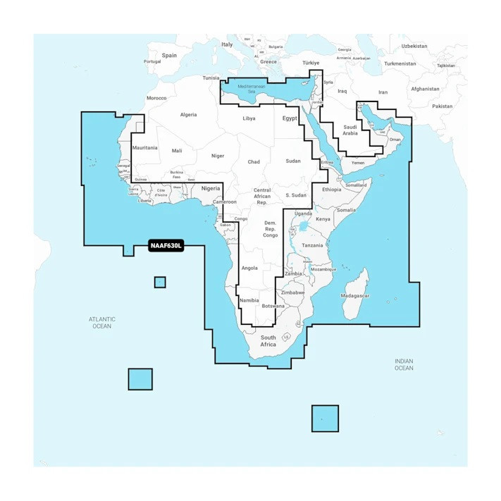
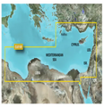
The Garmin Navionics+ Africa & Middle East Marine Charts provide detailed digital marine cartography for boaters navigating coastal waters and ports across the African and Middle Eastern regions. This chart package is designed to help users plan routes, identify navigational features, and better understand coastal waters when used with a compatible chartplotter.Garmin Navionics+ Africa & Middle East Marine Charts - DescriptionThe coverage includes extensive coastal areas around Africa and the Middle East, with chart data covering important maritime regions such as the Red Sea, Arabian Peninsula, Persian Gulf, Madagascar, and other surrounding areas. The package is supplied in a large coverage format and includes a one-year subscription for available chart updates and additional Navionics+ features.
1. Detailed Regional Marine Mapping This chart package gives boaters access to marine mapping focused on Africa and the Middle East, helping them plan journeys and navigate familiar or unfamiliar coastal waters. 2. Extensive Coastal Coverage The mapping extends across numerous important maritime areas, including sections of the African coastline, the Red Sea, the Arabian Peninsula, the Persian Gulf, and nearby islands and territories. 3. Useful Port Information The coverage includes major ports and coastal locations such as Dubai, Cape Town, Alexandria, Djibouti, Manama, and Lagos, making it useful for route planning around significant maritime destinations. 4. Designed for Compatible Chartplotters The marine charts are intended to be used with compatible chartplotter systems, giving boaters access to regional cartography directly through their supported marine navigation equipment. 5. One-Year Subscription Included The package includes a one-year subscription that provides access to available daily chart updates and other included Navionics+ content during the active subscription period. 6. Convenient Digital Chart Format The chart package is available as a microSD/SD card format, providing a convenient way to load marine cartography onto supported compatible equipment. Garmin Navionics+ Africa & Middle East Marine Charts - Key Features1. Africa & Middle East Regional Coverage Provides marine chart data covering a broad selection of coastal waters and navigational areas throughout Africa and the Middle East. 2. Large Coverage Area The regional mapping encompasses extensive coastal zones, including areas from North Africa through the Red Sea and around the African coastline, along with the Arabian Peninsula and Persian Gulf. 3. Major Maritime Destinations Included Chart coverage includes key locations and ports such as Dubai, Cape Town, Lagos, Alexandria, Djibouti, and Manama, supporting navigation planning around important coastal destinations. 4. microSD/SD Card Format The physical chart format allows compatible users to insert the mapping card directly into supported marine electronics for convenient access to the included cartography. 5. One-Year Navionics+ Subscription A one-year subscription is included with the purchase, providing access to available updates and subscription-based features during the included period. 6. Chart Updates Through ActiveCaptain Compatible users can access available daily chart updates and additional content through the ActiveCaptain app while the included subscription remains active. 7. Supports Route Planning The detailed regional marine cartography helps boaters review coastal areas and plan navigation routes before and during their journeys. 8. Useful for Coastal Navigation The coverage is particularly suited to boaters travelling through the included African and Middle Eastern coastal regions, helping them access regional chart information on compatible navigation systems. 9. Wide Regional Compatibility The chart package is intended for use with compatible chartplotters and marine navigation equipment. Device compatibility should be confirmed before purchase. 10. Navionics+ Cartography The product uses Navionics+ marine chart technology, providing a dedicated digital mapping solution for compatible marine electronics. What's in the Box
Note: Compatibility with the intended chartplotter should be verified before purchase. The included subscription provides access to available updates and subscription features for one year; continued access to new updates after that period requires an active subscription.
Specifications
|